Forecasting examples
Effectiveness and accuracy of the forecast is confirmed by specific examples comparing prognostic layout and available actual data. Moreover the author originally knew only the topographic base and reference ore mineralization.
---
The first forecast was made for one of Russian mining companies. As reference ore mineralization is taken deposit more than in 100 km from forecasting area, in similar geological and geomorphological situation. Non-singular mineralization within the most explored sites containing more than # at the depth up to #m and supported by results of heavy mining and drilling works and generally coinciding with contours of commercial mineralization is taken as "ore" standard.
State survey map with 1:50000 scale was used for research.
Company asks for non- mention region and deposit’s name so in present time on given objects conduct actives prospecting work.
Example 1 (look pic - its better to increase)
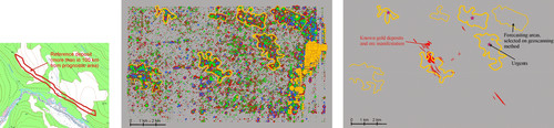
Selected 7 perspectives sectors, one of them coincides with well-known deposit and 3 another coincides with geochemical and geophysical anomalies, results of geological researches, sampling data, and selected as high-priority.
On the east of forecasting area, along river valley, were took symbolic significances of isolines because of absence of relief isolines.
Forecasting objects enough locals. In more detail (including on level of ore bodies) in this scale topographical map “ore signal” select it is impossible, need it scale as minimum 1:25000. The points of relief measures (accuracy) arranges every 120 m. In all on area come out more then 10000 reliefs “samples”.
In general on reference deposit predominates isometric relief forms. This one can to expect on forecasting area, this is a sort ore guide.
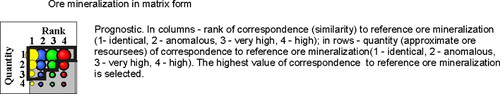
Forecasting maps constructed in form bubbles diagrams of Excel (coordinates X, Y and significances in form of size bubbles). Diagrams are “living”, they can be changed. With operating formulas easy to change a visualization of forecasting maps (when it changes parameters it can considerable change because of scales effects).
In general come out what “ore signal” in average correspond to reference deposit (not much big blues bubbles on diagrams with high significances correspondence to reference ore mineralization). But much reds bubbles (low level correspondence to reference ore mineralization), although they enough big. (Look legend).
When conducting prospecting should be considered that each part of the forecast objects may be shifted by 200-600 m (for scale 1:50000) from the real position ore mineralization. Presumably as the scale of geoscanning becomes larger, the forecast areas are more and more localized and shifted to the real position ore mineralization.
---
The second forecast was made for Russian company “Highland Gold Mining Limited” near gold-silver deposit Belaya Gora. As reference ore mineralization was took deposit inside of forecasting area. Non-singular mineralization within the most explored sites containing more than # g/t at the depth up to #m and supported by results of heavy mining and drilling works and generally coinciding with contours of commercial mineralization is taken as "ore" standard.
State survey map with 1:50000 scale was used for research.
Gold-silver deposit Belaya Gora located on the left bank of the river Amur in Nikolaevsk region of Khabarovsk krai, in 83 km from Nikolaevsk-na-Amure town.
It located within the lowered tectonic block which limits from north and south latitudinals faults. In centre of block covering volcanites are break through of neck of dacites, trachytes and etc., which was broke of faults northern and north-western direction. Submeridianals faults divides neck on west and east extrusions. Belaya Gora deposit spatially and genetically is connected with western extrusion.
Almost all rock in deposit limits hydrothermally arechanged from kaolin-sericitic to sericit-quartzose and up to seconds quartzites and hydrothermal breccias. A rocks which contains ore are metasomatites. Rocks of deposit often are fissurals, up to formation crushed zones. A rocks of deposit on majority sectors penetrates small and thin quartzoses, adularia-quartzoses, pirite-quartzoses streaks.
Ore mineralization is zones of mineralizeting explosives breccias, linears stockworks in subvolcanic intrusions, more seldom linears zones of vein-streak mineralization in rocks which contains ore.
Ore mineralization have streak-embedded, cluster character. It is no fixed by any geological indications and clearly defined only on sampling data.
In deposit limits stands out two ore zones: Stockwork and Sloping which breaks up sub latitudinal fault. These are stockworkal deposit which stretchs in north-eastern direction and are characterized of uneven gold distribution.
Stockwork ore zone. Maximum vertical ore score – 310 m. In zone limits selected 41 ore bodies. Ore bodies’ extension is north-eastern, fall south-eastern. In average falling angles are 30-400. Ore bodies have very complex morphology and intrinsic structure. Theirs thickness from 0.5 to 73.7 m. At depth ore bodies gradually wedge out.
Sloping ore zone. It has more simple morphology. In zone limits selected 9 ore bodies. Ore bodies’ extension is north-eastern, fall is south-western and fluctuates from 50 to 150. An ore bodies thickness changes from 0.9 to 26.6 m. Balance reserves of zone are worked out.
Example 2 (look pic.)

Forecast results
On ore reference mineralization and forecasting objects very expressed theirs dependence from latitudinals, submeridianals and north-easterns structures, these objects as if scueezed among faults of these directions.
In all selected 11 forecasting objects – 5 are paramounts (1-5) and 6 are secondary (apparently with poorer mineralization). Specially stand out linear arrangement of objects along submeridianal fault in central part of forecasting area. Reference ore mineralization (projections of ore bodies on horizontal plane) marked of a yellow bubbles concentration.
Object 2 practically completely coincides with well-known deposit. Objects 4 and 5 located in perspective area limits where at present conducting prospecting works. Moreover object 5 coincides with sector carrying out gold-digger’s extraction. Object 1 is missed (with this fully agrees the customer) –In former time gold placer was processed here, and practically always on this forecasting area under placer is primary deposit. Well-known deposit on the very north forecasting area geoscanning method non-reveals.
Forecasting objects enough locals. For more detail forecast (including on level of ore bodies) need scale as minimum 1:10000. The points of relief measures (accuracy) arranges every 120 m. In all on area come out more 8500 relief “samples”.
Bubbles concentrations with big size, including on reference ore mineralization (here they are yellow color), shows or on concretes ore bodies, or on sectors with more rich contents.
In general come out what “ore signal” in average correspond to reference deposit (not much big blues and yellows bubbles on diagrams with high significances correspondence to reference ore mineralization). But enough much reds and grins bubbles (not very high level correspondence to reference ore mineralization). Apparently it is connected with considerable unevenness of ore content (Look legend).
When conducting prospecting should be considered that each part of the forecast objects may be shifted by 200-600 m (for scale 1:25000) from the real position ore mineralization. Presumably as the scale of geoscanning becomes larger, the forecast areas are more and more localized and shifted to the real position ore mineralization.
---
These examples can be the main conclusions:
- ore signal pattern in auxiliary space was almost identical on, i.e. if we know mineralization of certain contours we can easily and precisely define other contours. Only the last will be as not completely developed photo;
- areas of forecasting mineralization are either completely confirmed by sampling of heavy mine working and drill holes or verification of mineralization was never conducted there.
Back Next
|